OceansMap

SARMAPweb

SARMAPWeb is a powerful, cloud-enabled search and rescue modeling solution within OceansMap, designed to help responders rapidly predict the drift of missing persons, vessels, and objects. Built on over 25 years of proven SARMAP technology, it delivers fast, reliable insights to support life-critical decision-making in marine, freshwater, and aeronautical environments.


What is SARMAPWeb?

SARMAPWeb brings the industry-leading SARMAP modeling engine into a modern, browser-based environment. Integrated within OceansMap’s Incident Management Tool (IMT), it allows users to easily create, run, visualize, and share search and rescue scenarios—without the need for desktop software.

Whether responding to an active incident or planning exercises, SARMAPWeb provides a centralized platform for modeling drift behavior and coordinating response efforts in real time.

Why It Matters

In search and rescue operations, time and accuracy are critical. SARMAPWeb helps organizations:

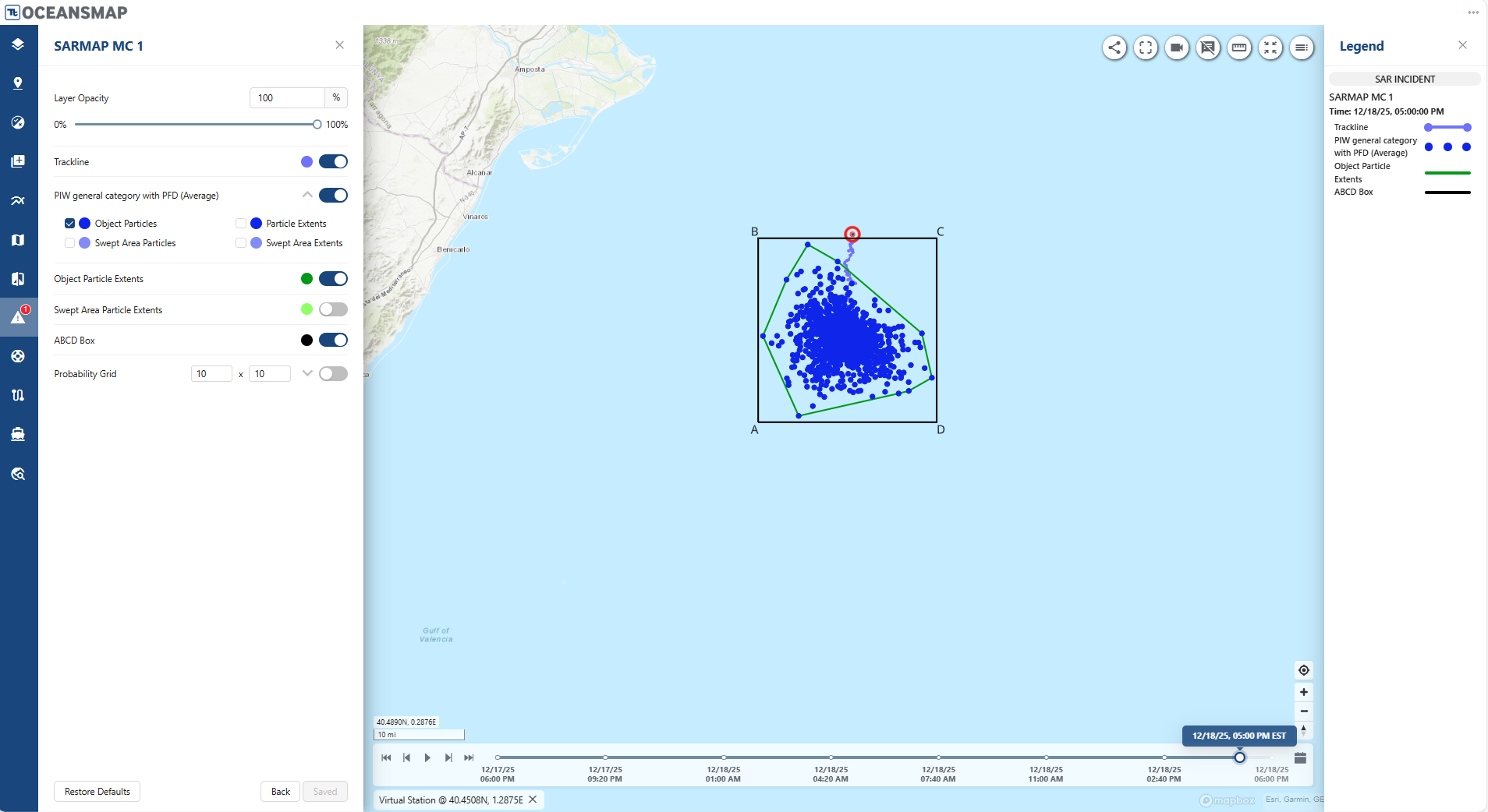
  • Reduce search areas quickly using scientifically validated drift models
  • Improve response coordination with shared, cloud-based scenarios
  • Make better decisions faster with real-time environmental data and visualizations
  • Train and plan effectively with repeatable, scenario-based simulations

Used by coast guards, naval agencies, and governments in over 100 countries, SARMAP has a long-standing reputation for reliability in operational environments.

SARMAP drift tracks

Key Capabilities

Advanced Drift Modeling


SARMAPWeb uses sophisticated trajectory modeling powered by wind and current forecasts to predict how objects move over time. It incorporates:

  • IAMSAR-compliant search planning methods
  • Monte Carlo simulations for uncertainty analysis
  • A comprehensive object database based on U.S. Coast Guard data

Fast Scenario Setup (“First Strike”)


Quickly initiate simulations with simplified inputs to support rapid response during the critical early stages of an incident.

  • Model up to 9 objects simultaneously
  • Start scenarios using drawn inputs or uploaded tracklines (GeoJSON or shapefiles)
  • Generate immediate trajectory predictions and search areas

Cloud-Based Data Integration


SARMAPWeb runs on Tetra Tech’s Model Data Service (MDS), a cloud-based system that combines modeling and environmental data services.

  • Access real-time wind and current forecasts via EDS
  • Run simulations without local compute requirements
  • Scale easily across teams and regions

Visualization & Analysis


Understand and communicate results clearly with built-in visualization tools:

  • Animated drift trajectories
  • Time-series outputs and reports
  • Exportable maps, graphics, and data products

Integrated Incident Management

Because SARMAPWeb is embedded within OceansMap’s Incident Management Tool, it goes beyond modeling to support full operational workflows:

  • Group and manage multiple scenarios in one place
  • Visualize multiple simulations simultaneously
  • Deploy and track search & rescue units within scenarios
  • Share results instantly across teams and stakeholders

This integration enables seamless collaboration between analysts, responders, and decision-makers.

SARMAP drift tracks

A Proven Model, Now More Accessible Than Ever

The SARMAP model has been trusted globally for decades. With SARMAPWeb in OceansMap, that same capability is now:

  • Web-based and accessible anywhere
  • Easier to use in time-critical situations
  • Designed for collaboration across teams

It’s a modern evolution of a proven system, helping you respond faster, coordinate better, and save lives.

SARMAP drift tracks

Contact Us